|
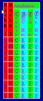
"Backg" refers to background layers, ie layers for which no data is available.
"NONE" means there is nothng in Background 1 here.
County is Background 1 here, and the RDC, FIA or Physiographic layer is in Background 2.
|
|
|
|
"Attributes" refers to the active layer, ie the layer for which data is available.
Attribute letters are hyperlinked - click any one to display a map with an active layer and non-active background layers. Then click on the active regions to get extensive forestry information related to that region. For more detailed instructions, see User Guide at left. |